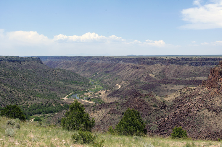
That’s the BLM Orilla Verde (“Green Bank”) Recreation Area site below on the Rio Grande. Cool, huh?


Previous post: Yesterday Evening
Next post: Old Taos Evening

by John Hamilton Farr on June 12, 2012 · 2 comments
in Rio Grande
• FotoFeed features almost 3,000 images, and you can view almost ALL of them sequentially, backwards or forwards . The current WordPress site goes back to June 14, 2009. On that page is a link to the last page of the preceding site, which goes all the way back to December 15, 2001.
• To see all photos starting from the present, just hit the "Previous Entries" or "Previous Post" links and work your way back.
• Unfortunately, you can't go forward from the oldest page (12-1-2001). But you can go from forward starting from January 5, 2006. From the preceding page, however, you can only go backwards to the beginning. Confusing, I know.
• The Photos by Category, Archives, and Search FotoFeed menus [right] only apply to the current site, going back to June 14, 2009, but you can find all kinds of interesting things.
• You can also use the Sitemap pages to search for photos at the current site by category and titles in a list format. Try it!

FotoFeed © 2009 - 2012 John Hamilton Farr, all rights reserved.
JHFarr.com Administrative HQ
Email: jhfarr@newmex.com


{ 2 comments… read them below or add one }
omg i so gotta see that!
The entrance to the Taos Valley Overlook is really hard to spot. If you’re coming from the south, it’s about 5 miles south of Taos, but after you drive through the Horseshoe and up on top again. If the speed limit drops to 50 and you see Stakeout Dr. on your right, you’ve missed it and need to turn around. There’s no sign, really, just a tiny brown thing with a hiker icon on it.
The spot above is at the end of the Trader’s Trail. That one goes mostly straight to where I took the picture, about 1.9 miles, or 3.8 miles round-trip. Note that the scale shown on the map at the site is WAY off.